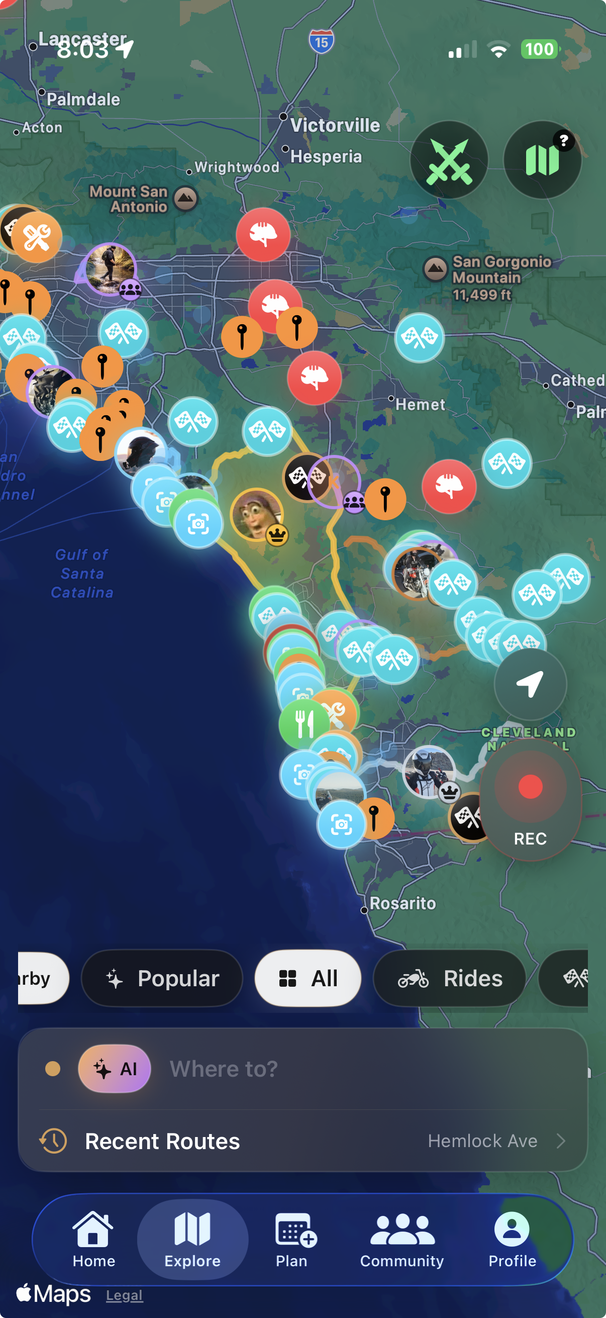
Laguna Coast Short Hop, Malibu Pier to Point Dume, Leo Carrillo to Point Mugu Rock, Ventura Pier to Carpinteria Bluffs, Gaviota Coast Scenic 101, Big Sur segments, Ortega Highway, Palomar, Sunrise Highway, and Montezuma Valley Road.
Rides
Find the roads riders actually use.
Rippin rides pages are built around real route demand: local motorcycle roads, rider comments, in-app segments, squad planning, and the roads the community can add next. Start with the map, then jump into the states where the app already has segment coverage.
Click a region.
San Diego is fully live. The highlighted states below already have Rippin segments in the app.
Where we have info
Current ride-guide coverage.
California motorcycle rides and routes
Big Sur, Malibu, Ortega, Angeles Crest, Palomar, Sunrise Highway, and Rippin coast segments.
Jump to notes San DiegoSan Diego motorcycle rides and routes
Palomar, Julian, Sunrise Highway, Banner Grade, East County, coastal rolls, Rippin segments, and community roads.
Open the guide TexasTexas motorcycle rides and routes
Hill Country, Lime Creek, FM 1431, Devil's Backbone, Twisted Sisters, River Road, and track-day anchors.
Jump to notes NYCNYC motorcycle rides and routes
Bear Mountain, Seven Lakes, Storm King, Hawk's Nest, Catskills, Adirondacks, and Northeast state roads.
Jump to notes FloridaFlorida motorcycle rides and routes
Ozello Trail, A1A, the Keys, Tamiami Trail, Big Cypress, Green Swamp, Sugarloaf, and Panhandle forest roads.
Jump to notes HawaiiHawaii motorcycle rides and routes
Tantalus, East Oahu, Road to Hana, Haleakala, Waimea Canyon, Kohala Mountain, and Saddle Road.
Jump to notes Pacific NorthwestWashington and Oregon rides
North Cascades, Chuckanut, Stevens Canyon, Wind River, Crater Lake, McKenzie Pass, and Gorge roads.
Jump to notes SouthwestArizona, Nevada, New Mexico, and Utah rides
Mount Lemmon, Oak Creek, Coronado Trail, Red Rock, Valley of Fire, Turquoise Trail, Zion, and Highway 12.
Jump to notes RockiesColorado, Montana, Idaho, Wyoming, and South Dakota rides
Trail Ridge, Million Dollar Highway, San Juan, Beartooth, Going-to-the-Sun, Lolo, Chief Joseph, and Black Hills roads.
Jump to notes Appalachia + SouthSmokies, Georgia, Alabama, Ozarks, and Natchez Trace
Tail of the Dragon, Cherohala, Foothills, Back of the Dragon, North Georgia, Cheaha, Pig Trail, Talimena, and Trace.
Jump to notesCalifornia
One state, several completely different ride moods.
California pages need to split coast cruises from canyon riding. PCH, Big Sur, Malibu, and Santa Barbara are scenic planning roads; Angeles Crest, Big Tujunga, Ortega, Palomar, Sunrise, and Montezuma need more margin and better road notes.
Angeles Crest gets praise for views and practice, but riders repeatedly warn about gravel, night visibility, oncoming traffic over the double yellow, and mountain closures. Ortega is convenient for OC, but traffic and enforcement shape the ride.
Los Angeles / Malibu, Orange County, Big Sur, Bay Area, and Sierra passes should become their own child pages once we have enough local notes and app segment coverage.
Texas
Build Texas around Hill Country first.
Texas search demand clusters around Austin day rides, Hill Country loops, and the Twisted Sisters. The useful copy needs to distinguish quick Austin roads from weekend rides out near Leakey, Bandera, and Vanderpool.
Lime Creek Road, FM 1431 Cedar Park to Marble Falls, Park Road 4 - Inks Lake, Devil's Backbone, Willow City Loop, FM 337 Leakey to Vanderpool, and River Road near New Braunfels.
Lime Creek is treated like a short technical local road with driveways, narrow lanes, surface complaints, and too much mixed traffic. FM 1431 gets called out as the longer sweeper choice. Twisted Sisters should be framed as a weekend, not a rushed Austin out-and-back.
COTA, Harris Hill, Eagles Canyon, and MSR Cresson give Texas pages a second path beyond public-road riding: track days, schools, and squad meetups.
NYC
NYC rides start with escaping the city cleanly.
The useful NYC page is not about Manhattan streets. It is about where riders go once they cross the bridge: Bear Mountain, Harriman, Seven Lakes, Storm King, Hawk's Nest, Taconic, Catskills, Adirondacks, and longer Northeast plans.
Bear Mountain Seven Lakes, Hawk's Nest NY-97, Storm King Highway, Catskill Route 23A, Adirondack Route 73, and Taconic Parkway Scenic Run.
Kancamagus Highway in New Hampshire, Mohawk Trail in Massachusetts, and Vermont Route 100 give this cluster more than one quick metro escape angle.
Bear Mountain and Harriman are the usual quick escape. Storm King and Hawk's Nest make the longer loop feel worth it, but riders mention closures, police, damp shaded corners, rough patches, and heavy park traffic.
NYC metro, Hudson Valley, Catskills, and track-day pages for New York Safety Track, NJMP, and Lime Rock will make this useful beyond one weekend route.
Florida
Florida is a scenic-planning state, not a canyon state.
The Florida copy should be honest: riders search for technical roads, but the best value is coastal timing, heat planning, remote stretches, bridge runs, and low-speed backroad character.
Ozello Trail, The Old Brick Road, A1A Ormond to Flagler Beach, A1A Ponte Vedra to St. Augustine, Overseas Highway, Tamiami Trail Everglades, Loop Road Big Cypress, Green Swamp Loop, Sugarloaf Mountain Road, Tail of the Gecko, and Blackwater River Forest Run.
Lead with surface and weather: sand, wet brick, heat, tourist traffic, low sun, bridges, wildlife, and long fuel gaps matter more than corner count.
Florida Keys, Tampa / Sarasota backroads, Northeast Florida A1A, Central Florida, and Panhandle forest-road pages can each carry real local search demand.
Hawaii
Island rides need local etiquette baked in.
Hawaii pages should be scenic and practical: small-island traffic, wet shade, one-lane bridges, tourism pressure, neighborhood noise, fast weather, and limited shoulder space.
Tantalus Round Top Loop, Kalanianaole East Shore, Hana Highway Paia to Hana, Haleakala Highway Climb, Waimea Canyon Kokee Climb, Kohala Mountain Road, and Saddle Road Mauna Kea Crossing.
Separate Oahu quick rides from Maui, Kauai, and Big Island day plans. The notes should mention wet leaves, tour vans, one-lane bridges, wind, fog, altitude, and respecting neighborhoods.
Oahu, Maui, Kauai, and Big Island deserve their own pages once we add photos, fuel-stop notes, and rider-submitted segment context.
Pacific Northwest
Washington and Oregon need season and surface notes up front.
PNW pages should treat road status as part of the route. Some of the best roads are seasonal, damp, forested, or traffic-heavy near viewpoints.
North Cascades Highway, Chuckanut Drive, Mount Rainier Stevens Canyon, Wind River Road, Crater Lake Rim Drive, Aufderheide Scenic Byway, Historic Columbia River Highway, McKenzie Pass, and Rowena Loops.
Call out seasonal openings, wet mossy shoulders, forest debris, cyclists, tourists stopping at viewpoints, logging traffic, and quick temperature changes.
Seattle / North Cascades, Portland / Columbia Gorge, Oregon Cascades, and Crater Lake can all become strong regional pages.
Southwest
Desert states need fuel, heat, and remoteness handled cleanly.
The Southwest has huge search value, but the page should make planning obvious: heat, closures, park rules, long gaps, mixed pavement, tourists, and no-service stretches.
Mount Lemmon Highway, Apache Trail to Tortilla Flat, Bartlett Lake Road, Yarnell Hill, Salt River Canyon, Oak Creek Canyon, Coronado Trail, Senator Highway, Route 66 Oatman Highway, Red Rock Canyon Loop, Valley of Fire Highway, Mount Charleston Kyle Canyon, Turquoise Trail, Utah Scenic Byway 12, Zion-Mount Carmel Highway, Alpine Loop Scenic Byway, and Mirror Lake Highway.
Segment notes should say when the road is a scenic cruise versus a technical road. Arizona can be heat and debris. Nevada can be park traffic and exposure. Utah can be remote and seasonal.
Phoenix / Tucson, Sedona, Las Vegas, Southern Utah, and Albuquerque / Santa Fe are the natural SEO splits.
Rockies + Black Hills
High-country roads need pass conditions, altitude, and weather context.
These pages should not read like generic “best twisties” posts. They need pass names, seasonal caveats, traffic notes, and enough planning detail to help a rider choose the right day.
Trail Ridge Road, Million Dollar Highway, Independence Pass, Peak to Peak Highway, San Juan Skyway, Golden Gate Canyon Road, Guanella Pass, Lookout Mountain Road, Poudre Canyon, Storm Mountain Drive, Beartooth Highway, Going-to-the-Sun Road, Lolo Pass, Chief Joseph Scenic Byway, Needles Highway, and Spearfish Canyon.
Call out altitude, no-guardrail exposure, tourists, wildlife, rockfall, wet shaded turns, pass closures, and the difference between scenic park roads and technical canyon roads.
Colorado Front Range, San Juan / Million Dollar Highway, Montana passes, Idaho / Lolo, Wyoming / Beartooth, and Black Hills pages should be split by trip style.
Appalachia + Southeast
This is where the “how to ride it” notes matter most.
The Southeast has legendary route names, but it also has enforcement, traffic, blind corners, damp shade, gravel, and roads riders treat with real respect.
Tail of the Dragon, Deals Gap Loop, Moonshiner 28, Diamondback 226A, Blue Ridge Parkway, Cherohala Skyway, Foothills Parkway, Back of the Dragon, Blood Mountain US-129, Wolf Pen Gap Road, Richard B. Russell Scenic Highway, Georgia 60 to Suches, Cheaha Road, Ozark Pig Trail, Talimena Scenic Drive, and Natchez Trace Parkway.
The copy should separate technical roads from scenic parkways. Dragon-area pages need first-pass warnings, pull-off culture, enforcement, photographers, and why smooth beats fast.
Deals Gap / Smokies, Asheville / Blue Ridge, North Georgia, Alabama / Barber weekend, Arkansas Ozarks, and Natchez Trace can become separate guides.